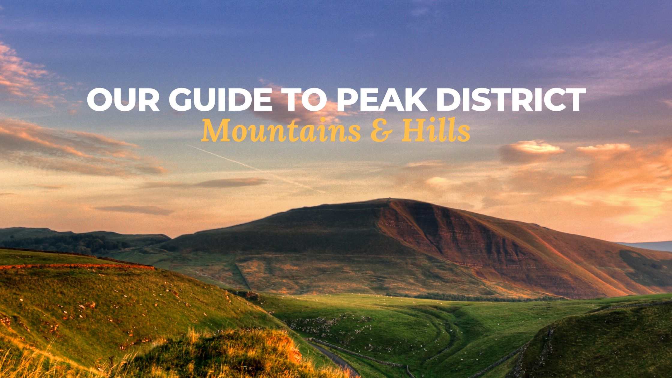
Our Guide to Peak District Mountains and Hills
Friday 31st January, 2025 by Host & Stay
The Peak District is a haven for outdoor enthusiasts, offering a stunning mix of rolling hills, rugged moorlands, dramatic peaks, and breathtaking waterfalls. Whether you’re an experienced hiker seeking a challenge or a casual walker looking for breathtaking views, the Peak District mountains and hills on offer provide some of the most spectacular landscapes in the UK. From the windswept plateau of Kinder Scout to the iconic ridgeline of Mam Tor, each peak has its own unique character and rewards those who reach the summit with panoramic vistas. In this guide, we’ll explore some of the best hills and mountains in the Peak District, how to reach them, and the incredible views you can expect along the way.
STAY IN THE PEAK DISTRICT
Kinder Scout
At a glance:
- The highest point in the Peak District
- Stands at: 636 metres
- Time: 4 – 5 hours
- Difficulty: Moderate to strenuous
- Public transport: Edale Train Station
- Where to park: Main car park next to the village hall
Standing as the highest point in the Peak District at 636 metres, Kinder Scout is a vast moorland plateau that promises unparalleled views and a rich tapestry of natural features. The ascent to Kinder Scout is a rite of passage for many hikers, offering a blend of challenging terrain and rewarding scenery. Set in the Dark Peak, the views on clear days from the top are incredible! You can see Mount Snowdon to the west and even Manchester.
Useful information about Kinder Scout:
Route to the summit
The village of Edale serves as the primary base for those aiming to conquer Kinder Scout. From Edale, embark on the trail leading through Grindsbrook Clough. This route is renowned for its rugged beauty, featuring rocky scrambles and serene brookside paths. As you ascend, the landscape transitions from verdant valleys to the open expanses of the Kinder plateau.
Highlights
En route, hikers are treated to the sight of Kinder Downfall, the tallest waterfall in the Peak District with a 30-metre drop. On windy days, the waterfall’s spray is often blown upwards, creating a mesmerising spectacle.
Views from the top
Upon reaching the summit, you’ll be greeted with sweeping vistas that stretch across the Peak District and beyond. The plateau’s edges offer dramatic viewpoints, with sheer drops and panoramic scenes that are particularly captivating during sunrise or sunset.
Nearby attractions
After descending, consider exploring the village of Edale, known for its charming cottages and traditional pubs. The Old Nag’s Head provides a cosy spot to relax.
Public transport
The village of Edale has a train station (Edale Train Station, Station Road, Edale, Derbyshire, S33 7ZN) with regular routes to Manchester and Sheffield so it’s a fantastic choice if you’re travelling via public transport.
Where to park
Parking in the village of Edale is quite limited and can become full quickly especially on weekends and bank holidays. The main car park is next to the village hall (S33 7ZP) and has 138 parking spaces. It is £6 for over 4 hours (maximum of 10 hours) and the ticket machines in the car park are cash only but you can pay using PayByPhone too. Make sure to keep your eye out for parking restrictions and avoid parking on the grass or outside of the clearly marked spaces (traffic wardens are often around).
If the main car park becomes full, there is overspill parking at certain times throughout the year provided by the Parish Council. It will be signposted when in action and costs £5 per day with all funds raised going to local village groups and charities.
Another option is Edale Train Station which has 20 parking spaces and is £4 for 24 hours (you can pay using cash or card).

Mam Tor
At a glance:
- Known as ‘The Shivering Mountain’
- Stands at: 517 metres
- Time: 1 – 2 hours
- Difficulty: Easy to moderate
- Public transport: 272 bus route or Hope (Derbyshire) Train Station
- Where to park: Castleton long stay car park
Mam Tor, affectionately termed the ‘Shivering Mountain’ due to its frequent landslides, stands at 517 metres and offers some of the most accessible yet rewarding hikes in the Peak District. Its name translates to ‘Mother Hill’, a nod to the mini hills formed by historical landslides on its eastern face. Sat on the boundary of the Dark Peak and the White Peak, Mam Tor is one of the busiest Peak District mountains and the route to the top is certainly well travelled throughout the year.
Useful information about Mam Tor:
Route to the summit
The village of Castleton provides a convenient starting point, with ample parking and amenities. A well-trodden path leads directly from the car park to the summit following the ridge of a hill between Great Ridge in the west and Rushup Edge in the east. The route is relatively short, taking about 1 to 2 hours to complete, making it suitable for families and casual hikers.
Highlights
The trail is well-paved and offers interpretative signs detailing the area’s geology and history. As you ascend, the views of the surrounding valleys and ridges become increasingly expansive.
Views from the top
From Mam Tor’s summit, hikers are rewarded with 360-degree vistas encompassing the Hope Valley, Edale Valley, and the striking ridgeline of the Great Ridge. Rolling green fields and rugged hills create a picturesque panorama that’s especially photogenic during the golden hours of dawn and dusk.
Nearby attractions
Post-hike, delve into Castleton’s attractions, such as the Blue John Cavern and Treak Cliff Cavern, where you can discover the unique Blue John stone. Winnats Pass, a dramatic limestone gorge, is also nearby and offers additional walking opportunities.
Public transport
If you’re travelling via rail, the closest train station is Hope (Derbyshire) Station (Station Road, Hope, Derbyshire, S33 6RD). It’s roughly two and a half miles east of Castleton and has regular routes to Sheffield and Manchester.
The 272 bus service runs hourly from Sheffield.
Where to park
Castleton long stay car park (Cross Street, Castleton, Hope Valley, Derbyshire, S33 8WH) has 133 spaces and is open 24 hours. It’s a pay and display car park where you can pay using cash, card or PayByPhone. It is £4.50 for 2-4 hours or £6.80 for over 4 hours (maximum of 10 hours).
Win Hill
At a glance:
- Overlooks the serene waters of Ladybower Reservoir
- Stands at: 462 metres
- Time: Roughly two hours
- Difficulty: Moderate
- Public transport: 257 bus route
- Where to park: Heatherdene Car Park
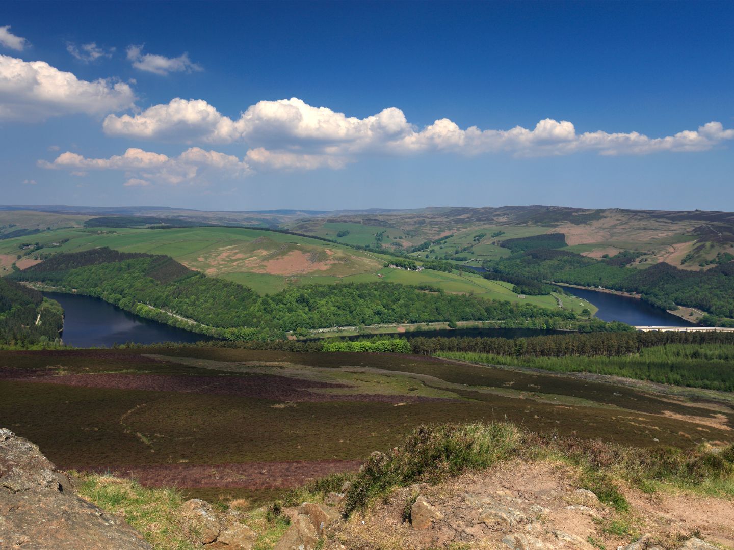
Overlooking the serene waters of Ladybower Reservoir, Win Hill stands at 462 metres and is celebrated for its distinctive conical shape and commanding views. A challenge to climb, reaching Win Hill Pike (also known as the Pimple) at the top is a Duke of Edinburgh Award station.
Useful information about Win Hill:
Route to the summit
The village of Hope or the Yorkshire Bridge area are popular starting points for climbing Win Hill. The most challenging of the routes starts from Yorkshire Bridge and ascends via the steep Parkin’s Clough which involves a 980ft climb in just three quarters of a mile.
If you’d prefer a more gradual climb, consider the path from Hope which meanders through woodlands and open fields before reaching the summit.
Highlights
The trail from Hope offers a diverse landscape, including ancient woodlands, heather-clad moors, and glimpses of the reservoir below.
Views from the top
At the summit, hikers are treated to panoramic views of the Ladybower Reservoir, the Derwent Valley, and the opposing peak of Lose Hill. On clear days, the distant cityscape of Sheffield can also be seen.
Nearby attractions
The nearby Ladybower Reservoir offers scenic walking and cycling routes. The Derwent Dam, famous for its role in the Dambusters training missions during World War II, is also worth a visit.
Public transport
Public transport to Win Hill is limited. However, the 257 bus route from Sheffield travels just outside Heatherdene to the Ladybower Inn.
Where to park
Heatherdene Car Park (A6013, Hope Valley, S33 0BY / What3words: ‘beads.rigs.jetting’) is the best parking option but it’s worth noting that it does get full very quickly especially on weekends and during the summer. It cost £3.50 for two hours or £6 all day, and you can pay by cash or card. Amenities in the car park include toilets, boot washing stations, picnic benches and a water refill point so it’s well equipped for starting the hike up to Win Hill.
As well as the car park, there are a free parking spaces available in nearby lay-bys, but these spaces are limited and fill up quickly.
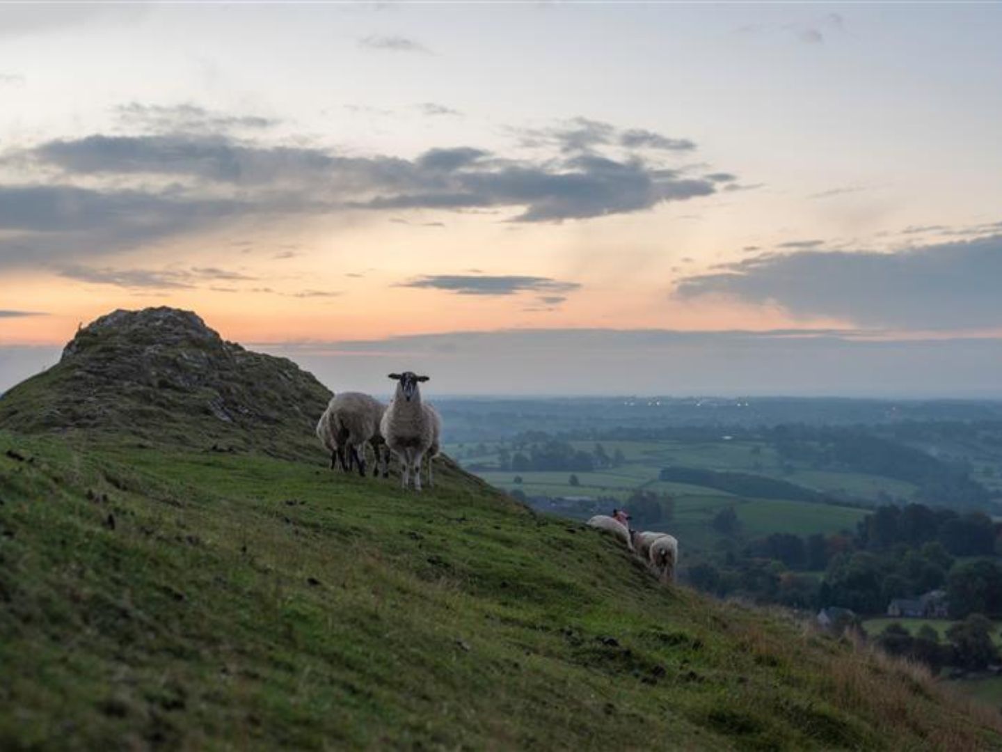
Thorpe Cloud
At a glance:
- Made of limestone formed over 350 million years ago
- Stands at: 287 metres
- Time: Roughly 30 minutes
- Difficulty: Moderate
- Public transport: No public transport
- Where to park: Narlows Lane Car Park or Thorpe Station Car Park
This striking limestone hill is in the southern part of the Peak District on the border of Derbyshire and Staffordshire. It sits at the entrance to the famous Dovedale Valley, known for its stunning scenery and the River Dove, which flows through the area. At the base of the hill, the well-known Dovedale Stepping Stones cross the river, attracting walkers and photographers. Thorpe Cloud stands at 287 metres and offers breathtaking panoramic views of the surrounding countryside.
Thorpe Cloud is made of limestone which formed over 350 million years ago and it’s particularly magical here at certain times of the year when there is a double sunset! Visit around summer solstice time to try and catch this peculiar phenomenon.
Useful information about Thorpe Cloud:
Route to the summit
The village of Thorpe provides parking facilities, with a short walk leading to the base of the hill. A well-marked path ascends directly to the summit. The climb is relatively short but steep in sections, making it suitable for most hikers with a reasonable level of fitness.
Highlights
The ascent offers continuous views of the surrounding countryside, with the meandering River Dove adding to the scenic beauty.
Views from the top
From the summit, there’s a commanding view of Dovedale, with its characteristic stepping stones and lush valleys.
Nearby attractions
After descending, explore Dovedale’s famous stepping stones and take a leisurely walk along the river. This stunning valley has limestone cliffs and caves making it a great place to discover.
Public transport
Unfortunately there aren’t any public transport options to the area at the moment.
Where to park
We’d recommend parking in Narlows Lane Car Park (Narlow Lane, Ashbourne, DE6 2AT) or Thorpe Station Car Park (Thorpe Station, Narlow Lane, Thorpe, DE6 2AT) which are within a few minute’s walk of each other.
Both car parks have 45 spaces and are pay and display (previously these car parks were free but this changed in November 2023). It is £1.50 for an hour, £2.50 for two hours, £4 for fours, and free between 6pm – 12am. It’s worth noting that you can only pay by card or RingGo.
Another option is Dovedale Car Park (Ilam, Ashbourne, Staffordshire, DE6 2AZ) but it’s worth noting that this car park can get very busy. It isn’t our first choice as the final stretch involves very narrow roads which can be a nightmare especially during peak times. Parking at Dovedale costs £6 for up to four hours or £8 for over four hours. It’s worth bringing the correct change for the car parking machine too! If you’re a National Trust member, you can park for free here but remember to bring your membership card to scan at the machine.

Chrome Hill and Parkhouse Hill
At a glance:
- Known as the ‘Dargon’s Back’ due to their unique ridged appearance
- Stands at: 425 metres (Chrome Hill) / 360 metres (Parkhouse Hill)
- Time: 2 – 3 hours
- Difficulty: Moderate to challenging
- Public transport: Limited
- Where to park: Main Street in Earl Sterndale
Often referred to as the ‘Dragon’s Back’ due to their unique ridged appearance, Chrome Hill and Parkhouse Hill are two of the most striking limestone peaks in the Peak District. These hills offer a dramatic and memorable hike, perfect for those seeking a slightly more challenging but immensely rewarding experience.
Useful information about Chrome Hill and Parkhouse Hill:
Route to Chrome Hill and Parkhouse Hill
The village of Earl Sterndale is a common base for this hike, with convenient parking and a picturesque setting. Begin by following the public footpaths leading towards Chrome Hill. The path winds through fields and climbs steadily, offering an exhilarating hike with steep sections. From Chrome Hill’s summit, follow the ridge to Parkhouse Hill for a truly dramatic experience.
Highlights
Both hills provide exciting ridge walks, with steep ascents and descents that are sure to thrill adventurous hikers. The unique geological formations make these hills stand out from other peaks in the district.
Views from the top
From the summits, the ‘Dragon’s Back’ ridge is fully visible, snaking through the landscape with a distinctive, undulating form. The surrounding scenery, dotted with dry stone walls and grazing sheep, is a quintessential Peak District view. On a clear day, you can see for miles across the White Peak countryside.
Nearby attractions
For a post-hike reward, stop by one of Earl Sterndale’s traditional pubs, such as The Quiet Woman, known for its cosy atmosphere and hearty meals.
Public transport
Public transport to Earl Sterndale is limited. There is a summer bus route from Buxton with High Peak and this service is number 442.
The closest train station is Buxton Train Station (Station Road, Buxton, Derbyshire, SK17 6AQ) which is five miles away.
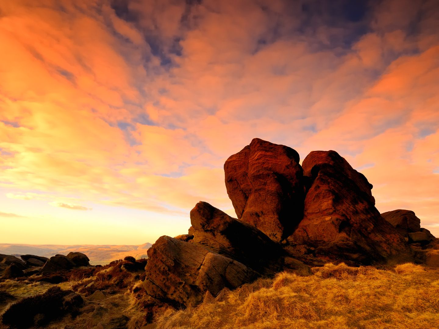
The Roaches
At a glance:
- A rugged landscape of dramatic rock formations and incredible views
- Stands at: 505 metres
- Time: 1.5 – 2 hours
- Difficulty:
- Public transport: No public transport
- Where to park: Layby parking along Roach Road
Whilst technically not a mountain or hill, we couldn’t miss The Roaches off our list! A series of gritstone escarpments, it’s one of the most popular walking and climbing destinations in the area, offering dramatic rock formations and rich wildlife. Rising to 505 metres, this rugged landscape offers enchanting woodlands and expansive views over the surrounding Staffordshire countryside.
Useful information about The Roaches:
Route to The Roaches
The Winking Man pub, located on the A53 near Leek, serves as a convenient starting point with parking available nearby. The trail to the summit follows a well-defined route, climbing steadily along the ridge. You’ll pass iconic landmarks such as Hen Cloud, Ramshaw Rocks, and the famous Doxey Pool, a mysterious pool said to be home to a mythical mermaid.
Highlights
Along the way, you’ll encounter dramatic rock formations, heather-covered moorland, and a variety of wildlife, including peregrine falcons.
Views from the top
From the summit of The Roaches, the Staffordshire Moorlands unfold before you, with sweeping views across Tittesworth Reservoir and the Cheshire Plain. The rugged terrain creates an otherworldly atmosphere, especially during sunrise or sunset.
Nearby attractions
After your hike, head down to Tittesworth Reservoir, where you can enjoy water sports, a picnic, or a walk along the reservoir’s tranquil shores.
Public transport
Unfortunately, there isn’t any public transport at the moment that leads directly to The Roaches.
Where to park
There aren’t any official car parks for The Roaches but there is generous layby parking along Roach Road where you can park for free. These bays can become full, especially on summer days, so we’d recommend trying the farm at Roaches Tea Rooms if that’s the case. They sometimes provide all-day parking in their field for a small price.

Planning your visit
When to visit
The Peak District mountains and hills are stunning year-round, but spring and autumn are particularly magical, with blooming wildflowers and vibrant autumn colours adding to the charm. Summer offers longer days for extended hikes, while winter brings a rugged beauty, especially after a fresh dusting of snow.
Footwear
Ensure you have sturdy hiking boots, as some trails can be steep and rocky.
Navigation
While many trails are well-marked, carrying a map or GPS device is recommended, especially for longer hikes.
Packing essentials
Bring plenty of water, snacks, and layers, as weather in the Peak District can change rapidly.
Stay in the Peak District
From the dramatic heights of Kinder Scout to the unique ridges of the Dragon’s Back, the Peak District mountains and hills offer an unforgettable outdoor experience. Whether you’re seeking challenging climbs, serene walks, or simply a chance to connect with nature, these peaks have something for everyone. Plan your visit today and discover the breathtaking beauty of the Peak District mountains for yourself!
At Host & Stay we offer a variety of accommodation options in the Peak District, from charming cottages to beautiful homes. Perfect for solo adventures, dog friendly stays, romantic retreats and family holidays, there is something for everyone here. From Matlock to Buxton, Bakewell to Ashbourne, an unforgettable stay awaits you in the Peak District.
EXPLORE OUR HOLIDAY LETS IN THE PEAK DISTRICT